Sunday, December 30, 2007

Dovestones Reservoir

Date of Walk : Sunday 25th.November

Had actually forgot that I'd not posted these pics, but due to a combination of the horrible weather and a huge flood in my kitchen have been unable to get out recently. It's a bit of a pain as I have a new Canon G9 which needs testing out in the hills. The walk was a 7 mile circular round the lower edges of Greenfield and Dovestones Reservoir.


Saturday, November 24, 2007

Blackstone Edge

Date of Walk : Sunday 18th November

Route : Ogden Reservoir - Kitcliffe Reservoir - Piethorne Reservoir - Windy Hill - Blackstone Edge - Lydgate - Ogden Reservoir

Distance : 10.4 miles


This was a walk with a new walking group (40s Walkers North) and the weather was pretty dire but the company was great and it was good to put names to faces. We set off from a rather damp Ogden Reservoir with a little excitement as sleet could be seen up on Crompton Moor. What is it that turns perfectly behaved adults into children when there's a bit of white stuff about. The walk continued up the Piethorne valley and then we headed up to Windy Hill. For those unfamiliar with the area it is the top of the M62 at Summit. Then we followed the Pennine Way path over Blackstone Edge. This saw quite a reasonable amount of snow as we gained height. After negotiating Blackstone Edge we came down the Roman Road and then followed the route back to the M62 before heading back down to Ogden Reservoir.

Ogden Reservoir


The path on the way up to Windy Hill

Not quite Striding Edge but it involved a bit of balancing.

Blackstone Edge

Flickr Album - Blackstone Edge - 18 Nov 2007


Sunday, November 11, 2007

Remembrance Sunday

Date : Sunday 11th November

Distance : 2.5 miles


It's certainly not the achievement of Great Gable and I promise to do that one year, but this is the local service on Pots & Pans which I have walked on plenty of previous outings.

Looking up Chew Valley.

Beth on the way up striking a pose.


Flickr Album - Remembrance Sunday

Haystacks

Date of Walk : Friday 2nd November

Distance : 4.5 miles

Route : Gatesgarth Farm - Warnscale Bottom - Haystacks - Scarth Gap - Gatesgarth Farm

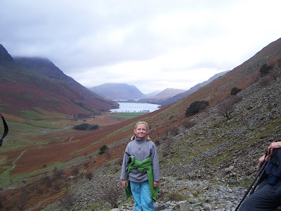
This was the last walk of our short break, and we also took my dad and stepmum along as well. This was a really enjoyable walk although it feels more than 4.5 miles. I would love to repeat it on a day with a little less cloud to get some even better images, but I suppose it is November.


Looking to where we are heading.


Buttermere and Crummock Water


Flickr Album - Haystacks - 2 Nov 2007

Mellbreak

Date of Walk : Wednesday 31st October

Distance : 6.2 miles


This was an excellent walk with Roger and Ann Hiley (plus Harry and Bethan of course). We met up at their cottage in Loweswater and decided upon heading up Mellbreak and headed for Scale Force before walking back along the shore of Crummock Water. It was great to finally meet up with Roger and Ann who were excellent hosts for the day as well as super company. Beth is also hooked on having a go at completing the Wainwrights but insists we need a dog to do it. I said we'll have to trade her older brother in for a dog!!


Ann and Beth leading the way (although Harry and Bethan are probably further ahead.)

Fleetwith Pike

Two Beths and Harry

Crummock Water and Buttermere

Scale Force

Beth helped Roger tidy up the old gate.

Beth after a quick shower and change!!

Flickr Album - Mellbreak - 31 Oct 2007

Loweswater Cam - report and photos on our walk


Ashness Bridge

Date of Walk : Tuesday 30th October

Distance : 6.2 miles

Route : Castlerigg Farm - Springs Wood - Keswick (town centre) - Friar's Crag - Calfclose Bay - Ashness Bridge - Great Wood - Castlerigg Farm


This was the start of our short break in the Lakes. The initial plan was to go up Walla Crag, but Beth wanted to pop down into Keswick. We went down to Keswick and walked along the side of Derwent Water and eventually arrived at Ashness Bridge. After leaving Ashness Bridge, the weather appeared to be turning a little grim, so we re-routed through Great Wood. My theory here was that if the heavens opened at least the wood would give us a little shelter. Of course, it never rained but Walla Crag can wait for another day.

Looking across Derwent Water.

Friar's Crag

Looking down Derwent Water towards Castle Crag.

Ashness Bridge


The view towards Bassenthwaite Lake.

Flickr Album - Ashness Bridge - 30 Oct 2007

Monday, October 29, 2007

Saddleworth Circular

Date of Walk : Sunday 21st October

Distance : 17.5 miles

Route : Shaw - Crompton Moor - Denshaw - Castleshaw - Standedge - Diggle - Uppermill - Dobcross - Delph - Denshaw - Crompton Moor - Shaw

The weather was unbelievable for October so the day couldn't be wasted. The plan was to go over the top of Crompton Moor (The same route as my last walk with Beth) and then head over to Castleshaw in the next valley via the village of Denshaw. From Castleshaw I went to the top of Standedge and then moved down the valley and followed the Huddersfield Canal all the way down to the outskirts of Uppermill. From here I picked up the old railway track (know locally as The Delph Donkey) and from Delph I continued up the valley and returned to Denshaw before heading back over Crompton Moor to home.

Residents of the llama farm in Denshaw.

Looking down to Castleshaw.

Castleshaw

There was once a Roman fort here.

The entrance to Standedge Tunnel.

The canal towpath on the route from Diggle to Uppermill

'The Delph Donkey'

Flickr Album - Saddleworth Circular - 21 October 2007


Sunday, October 14, 2007

Crompton Moor and beyond

Date of Walk : Sunday 14th October

Distance : 8.7 miles


Beth was out with me today so we walked over Crompton Moor and did a circuit of the reservoirs in the Piethorne valley. (Rooden, Kitcliffe, Piethorne and Ogden) We walked back through the woods but she was feeling a little tired so walked back along the main road from Ogden Reservoir.

Looking down to Ogden Reservoir from the path on Crompton Moor.

Beth with the mast at Summit (J22 of the M62) visible in the distance.

Which way is it?


Shall I leave you here?


Flickr Album - Crompton Moor and Reservoirs

Sunday, October 07, 2007

Black Hill & Chew Reservoir

Date of Walk : Sunday 30th.September

Distance : 13.5 miles


This was an excellent ramble with super weather for the end of September. It sort of covers a couple of walks I have done before. I parked at Binn Green, but walked round the reservoir and up the road rather than going over the moors. This doesn't make it as exciting, but probably knocks about an hour off the walk. Once at Chew Reservoir I continued towards Laddow Rocks and then picked up the Pennine Way and followed this up to the A635 (the main road between Greenfield and Holmfirth)

Chew Reservoir

Looking back to Chew Reservoir

Looking down the valley towards Crowden from Laddow Rocks

Crowden Great Brook

Black Hill summit

Looking down to Dovestones Reservoir from the A635 road

Flickr Album - Chew Reservoir & Black Hill - 30 Sept 2007

Monday, September 03, 2007

Easdale Tarn

Date of Walk : Wednesday 29th August

Distance : 6 miles


This walk was a request from Beth as it was the very first walk she did in the Lakes. It was quite interesting to watch as she raced ahead as she knew the route even without looking at the map. It was extremely busy on the way up but we went back down on the other side of the valley and hardly met a soul. I don't know why so many people go up and down on the same path. Beth had the same complaint as yesterday saying the walk was too short!! She'll be running up Blencathra soon at the rate she's going. Sadly this walk signalled the end of our Lakes trip but we'll back soon. Hopefully our next trip will be at October half term but we might manage to sneak a weekend in before then.

Sourmilk Ghyll and Beth

Looking down the valley

Easdale Tarn

A well earned rest.

Flickr Album - Easdale Tarn - 29 Aug 2007

Blog Counter